How did Google Maps know about North Korea's nuclear test site?
It's unlikely the king of search was privy to top-secret intel


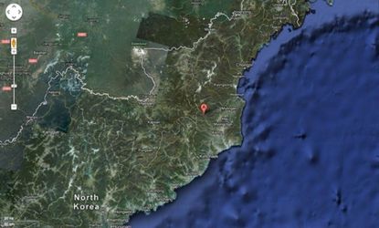
Of course North Korea conducted its nuclear test on Nuclear Test Road.
Indeed, that's the name Google Maps gives to a road just a few miles south of where North Korea's latest nuclear test appears to have taken place, based on U.S. Geological Survey data for seismic activity detected after the blast. What's more, a nearby building on that road is labeled "Nuclear Test Facility."
So did Google somehow know the location of the country's clandestine nuclear program? As it turns out, they probably didn't.
Subscribe to The Week
Escape your echo chamber. Get the facts behind the news, plus analysis from multiple perspectives.

Sign up for The Week's Free Newsletters
From our morning news briefing to a weekly Good News Newsletter, get the best of The Week delivered directly to your inbox.
From our morning news briefing to a weekly Good News Newsletter, get the best of The Week delivered directly to your inbox.
Last month, Google Maps rolled out newly detailed images of the isolated nation using information crowdsourced from Google Map Maker. The tool allowed "citizen cartographers," as Google called them, to add to and edit the North Korean map. Using that information, Google then transformed its image of North Korea from a blank white expanse to one populated with specific (though highly subjective) labels.
That update resulted in Google Maps identifying several interesting points within the country, including stores, subways, and the tomb of former leader Kim Jong Il. But it also led to the maps naming several sites as gulags, the brutal concentration camps critics and Korean defectors have long contended exist within the secretive nation. Through satellite images, Google Maps had previously shown what some claimed were these same concentration camps, but until last month, Google never labeled them as such.
"Nomenclature for points of interest come from and are moderated by the Map Maker community," a Google spokesperson told The Verge, referring the Gulag labels. "For any of our Map Maker countries — whether India or North Korea — we rely on users’ knowledge of a place, and other Map Maker users check and verify labels based on a variety of sources."
Google chairman Eric Schmidt visited North Korea in January, preaching the web's benefits in a country where internet access is notoriously limited. Shortly after he returned stateside, the new labels went live.
Sign up for Today's Best Articles in your inbox
A free daily email with the biggest news stories of the day – and the best features from TheWeek.com
Indeed, the nuke-related labels existed before last night's test. And given that they're crowd sourced anyway, it's unlikely Google was flaunting top-secret intel, but rather accepting what now appear to be good educated guesses from its users.
Create an account with the same email registered to your subscription to unlock access.
Jon Terbush is an associate editor at TheWeek.com covering politics, sports, and other things he finds interesting. He has previously written for Talking Points Memo, Raw Story, and Business Insider.
-
 Cicada-geddon: the fungus that controls insects like 'zombies'
Under The Radar Expert says bugs will develop 'hypersexualisation' despite their genitals falling off
By Chas Newkey-Burden, The Week UK Published
-
 'Voters know Biden and Trump all too well'
Instant Opinion Opinion, comment and editorials of the day
By Harold Maass, The Week US Published
-
 Is the Gaza war tearing US university campuses apart?
Today's Big Question Protests at Columbia University, other institutions, pit free speech against student safety
By Joel Mathis, The Week US Published